


Frequently asked questions
What is happening at Westleigh Park?
Purchased from Sydney Water in 2016, the 36-hectare Westleigh Park will play a key role in providing a recreational space for the Shire. The redevelopment will create a major parkland with spaces for play and sporting activities, and a choice of ‘unstructured recreation experiences’ including mountain biking, walking and cycling while conserving important bushland areas.
A draft Master Plan was first exhibited from 21 April to 16 June 2021. Following community engagement, the draft Master Plan was presented to a General Meeting on 14 July 2021. Councillors resolved to defer adopting the Master Plan to allow more time for staff to consult with the stakeholder groups to find solutions to the issues raised about mountain biking on the site and traffic management along Sefton Road.
Following stakeholder consultation, further refinements were made to the draft Master Plan and the revised draft Master Plan was available for community comment from 13 March to 11 April 2023.
The draft Plan of Management, detailing how Council will manage the community land at Westleigh Park, was on exhibition from 13 March to 11 April, with submissions accepted until 23 April 2023.
Both the Plan of Management and the revised Master Plan for Westleigh Park were adopted by Council on 14 June 2023.
Master Plan
The Master Plan sets out details on the types of suitable uses and activities that Council proposes to deliver within the park. The purpose of the Master Plan is to ensure Council will ultimately provide a new park at Westleigh with a range of recreational opportunities to enable broad use by the community.
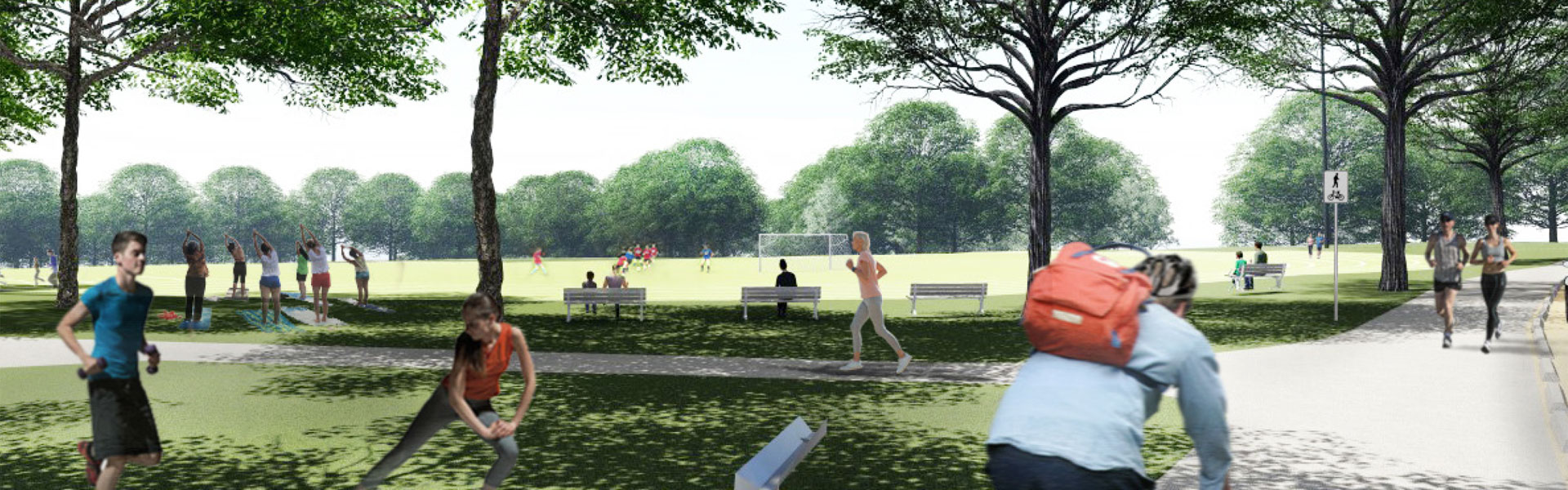
Westleigh Park will be a multi-purpose facility that will offer opportunities for active and passive recreation to cater for the diverse needs of the community.
Examples may include, but are not limited to:
- Community-based sport
- Opportunities for school and club athletics
- Cycling and mountain biking
- Informal exercising and walking
- Children’s playground
- Bushwalking
- Amenities
- Shared paths
- Passive recreation such as picnic areas with barbeques.
Sports Facilities Platforms
The Master Plan proposes three sporting platforms that have been designed to respect the existing bushland vegetation, whilst providing for future improved road access. These multi-use sporting fields will cater for Hornsby-based sporting club demands.
Athletics Track and Support Facilities
In the northern section of the cleared lands, a platform is proposed to provide a senior competition athletics track and an internal field area. This may be an all-weather elite athletics facility or alternatively a line marked grass track. Surrounding grassed areas are proposed to accommodate field events.
Central Multi-Purpose Sportsfield Platform
A multipurpose field platform is proposed in the centre of the site. This space could accommodate a synthetic surface or alternatively be developed as a natural turf sports surface. This field is intended for multiple sports and activities.
Southern Multi-Purpose Natural Turf Sportsfield Platform – Full Senior Size
The south of the site is the widest area where a sports field platform can be accommodated, while also protecting adjoining bushland. The Master Plan includes a multipurpose playing field platform with either two (2) full competition size football fields or a full-size AFL field, with a full-size cricket ground during summer.
Mountain Bike Trails and Bush Walking
The existing mountain bike trails and walking tracks will be either upgraded and improved or closed and rehabilitated. New trails will also be constructed to provide connections and alternatives to those being closed. The 6km of trails and tracks being proposed aims to provide a good quality and diverse user experience and protect the Park’s high value biodiversity
Improved Access for Traffic and Car Parking
As part of the Master Plan, the following access and parking improvements are proposed:
- new access road (extension of Sefton Road to Quarter Sessions Road)
- upgrade to the Sefton and Chilvers Roads intersection and
- 379 car parking spaces.
Throughout the development of the Master Plan, Council has been, and continues to be, committed to hearing from a range of voices. Key stakeholders, sporting user groups and the broader community were communicated with and involved in the consultation process.
The draft Master Plan was exhibited for a total of eight weeks from 21 April to 16 June 2021. During this time, we received 293 written submissions, held six stakeholder meetings which were attended by approximately 69 people and engaged with 785 people at three public ‘swing bys’.
There were also two surveys prepared as part of the community consultation. A total of 1,878 responses were received from Elton Consulting’s opt-in, online survey and a broader community representative, two stage phone/online survey by Micromex was completed by over 300 participants.
- View the Engagement Outcomes Report – Elton Consulting July 2021 (PDF 6.3MB)
- View Micromex’s phone survey results (PDF 3.5MB)
Following community engagement, the draft Master Plan was presented to a General Meeting on 14 July 2021. Councillors resolved to defer adopting the master plan to allow more time for staff to consult with the stakeholder groups.
Following the first period of community engagement in 2021, Council undertook workshops around traffic management issues with stakeholders and traffic management consultants as well as a series of co-design sessions for the mountain bike trails with key stakeholders.
The first four workshops on the mountain bike trails (attended by 78) were designed to identify and understand the values, priorities and concerns of the key stakeholder groups regarding Westleigh Park.
The final three co-design workshops were focused on working through the details of the ecological issues and trail design requirements. The outcomes of the stakeholder engagement were incorporated into a revised draft Master Plan which then went on exhibition from 13 March to 11 April 2023, providing further opportunity for the community to share its views.
View the Community Engagement Submissions Analysis Report – Urbis June 2023
Council has been working with Aboriginal Consultants and stakeholders to review conservation priorities and develop a Connecting with Country Framework to guide ongoing design refinement and development.
The preliminary Connecting with Country work is a brief outline of the discussions that took place during the onsite meetings and comments/recommendations supplied to date by the Registered Aboriginal Parties (RAP) to Wannangini Pty Ltd, the author or the report.
A preliminary Aboriginal Cultural Heritage Assessment Report (ACHAR) has been received with a particular focus on identified heritage items of conservation importance including a Scarred Tree on the site. Based on consultation and discussion with the RAP, the existing Scarred Tree (a dead Scribbly Gum) is proposed to be relocated and interpreted at the northern end of the northern field platform, connected with the valley landscape and bushland and providing a gathering and contemplation space.
The expected staging of Westleigh Park is:
- Adoption of Master Plan following community engagement (June 2023)
- Preparation and lodgement of a Development Application (July to September 2023)
- Development Application considered by an Independent Planning Panel (late 2024)
- Remediation and facilities works (Early 2025 to mid-2026)
- Stage 1 opens (mid 2026).
Stage 1 works would include:
- contamination remediation
- southern multipurpose natural turf sporting platform
- mountain bike trails
- amenities block
- stormwater management
- landscaping
- bush regeneration
- southern car park to the east of the sporting platform
- eastern and southern sections of the Sefton Road extension
- southern portion of internal park road linking to the amenities and the mountain bike trails.
The existing unsanctioned mountain bike trails will be either upgraded and improved or closed and rehabilitated. New trails will also be constructed to connect the upgraded trails and provide alternatives to those that will be closed.
Associated utilities would also be required to support the Stage 1 works, including an electrical substation kiosk, and water and sewer connections.
The extent of each future stage will be dictated by the funding that is secured. Work undertaken will be delivered in the most efficient way, balancing the operational needs of Stage 1 with the remediation requirements for the site.
Council is working to deliver both Hornsby Park and Westleigh Park and will stage the roll-out of both based on the availability of funding, whilst ensuring that they are delivered in a fiscally responsible manner that does not create any financial risk to Council.
After Council purchased the 36 hectare site from Sydney Water in 2016 for $21 m, the NSW Government allocated $40 million via the Stronger Communities Fund - to create Westleigh Park.
This amount will fund the entire Stage 1 works. Stage 2 of the project is entirely dependent on allocation of future funding sources. This will not occur until the completion of Stage 1.
Additional $3.5M funding has also been received to upgrade and build mountain bike trails in Hornsby Shire.
Once the detailed design is finalised, Council will then construct and deliver priority landscape embellishment finishes for the park as funding becomes available.
The land contains features of Aboriginal heritage significance. An assessment and consultation process with local Aboriginal representatives has been undertaken and an Aboriginal Cultural Heritage Assessment Report has been prepared.
Ongoing consultation and collaboration with the Registered Aboriginal Parties will inform a Connecting with Country framework, which will in turn guide ongoing design and development at Westleigh Park.
The preservation of critically endangered ecological communities and threatened species is essential to conserving the natural heritage of the area. The Master Plan has sought to deliver the advanced, intermediate and beginner mountain biking trail experience that is provided by the unsanctioned trails, noting that there is a need to protect high value biodiversity on the site.
Any residual impacts from the potential development and uses of the site will be subject to rigorous environmental assessment, consistent with legislation. According to the Master Plan, this includes the removal, relocation, upgrade and formalisation of existing unsanctioned mountain bike trails and the construction of roads and enabling infrastructure (e.g., retaining walls) for the sportsfields development.
All planning and design in these areas has employed the principles of ‘avoid, minimise and mitigate’ impacts to ensure the long-term protection of the ecologically sensitive areas, while still providing a quality recreational user experience. Further, in line with the Plan of Management, additional and ongoing restoration of the bushland will occur through a combination of revegetation and bush regeneration activities.
The unsanctioned mountain bike trails, some of which are through critically endangered communities, have existed for many years and were originally built by the mountain biking community while the land was in Sydney Water’s ownership.
Although the trails are unsanctioned, Council understands mountain biking remains popular within the community. Hence, the Master Plan aims to balance the competing priorities for this area by removing, recycling and upgrading trails to reduce their extent in areas of high value biodiversity.
Following extensive community engagement, including co-design workshops with key stakeholders, a concept design was developed. The concept design in the Master Plan aims to ensure the long-term protection of the ecologically sensitive areas, while still providing a quality riding experience.
The existing mountain bike trails will be either upgraded and improved or closed and rehabilitated. New trails will also be constructed to provide connections and alternatives to those being closed. The 6km of trail being proposed aims provide a good quality and diverse user experience, while protecting the high value biodiversity that exists on the site.
The current estimate is that the length of mountain bike trails within the bushland areas of the park will be reduced by around 30 per cent (from approximately 9km to 6km).
When the first stage of Westleigh Park is opened, it will look to include a connection to Hornsby Park. Most of the link between the two parks already exists in the form of maintenance trails (e.g. fire trails). Hence, the works involved in creating the connection will focus on the entry and exits to the parks and providing a safe creek crossing.
This connection will offer another experience to visitors of either park that can be enjoyed by those moving through the Shire on foot or bike.
There will be a buffer of bushland, around 150 metres wide, between the proposed sporting fields and the closest homes, which will minimise the impact of any noise and light on the nearby residences.
Those who use the site will need to abide by operating conditions, particularly in the evenings and early mornings. Nearby residents will be kept informed of these. Effects from sportsground lights will be minimised, ensuring compliance with Australian Standards for lighting and light spill.
The proposed link road, extending Sefton Road through the Sydney Water site to Quarter Sessions Road will provide an emergency access road for residents and response vehicles in the event of a bush fire.
The Sefton Road extension is required as an emergency access in the event of a bush fire, as well as for peak park usage periods only. It is not required to provide day to day through access.
Careful road design will ensure the opportunity for the road to be used as a ‘rat run’ is minimised, including the use of road barriers to prevent vehicular access outside of peak park usage times, such as opening on Saturday for weekly sports fixtures.
No, there are no additional access roads proposed on Kooringal Avenue of the powerline easement. A bike trail will connect to the park at the boundary of this property that includes the powerline easement, but there will no access from Kooringal Avenue.
As a part of Council’s negotiations with Sydney Water around access for the Westleigh Park project, Sydney Water required Council to investigate all possible access arrangements.
The traffic report has assessed these three options and found the Sefton Road extension provides the best connection. As reflected in the Master Plan, the extension of Sefton Road to Quarter Sessions Road is the only new access road being proposed as a part of the Westleigh Park project and Council has obtained in-principal support from Sydney Water for this road.
We’re currently finalising a traffic impact assessment with Bitzios Consulting and this will support the Quarter Sessions Road access for Stage 1 and the Sefton Road extension and Warrigal Drive access for Stage 2.
Plan of Management
A Plan of Management (PoM) is a document that provides Council with a clear framework for the use and management of all 'Community Land'.
A Plan of Management must:
- identify the important features of the land (i.e. natural significance, sportsgrounds, etc)
- establish how Council will manage the land
- indicate how the land may be used or developed (i.e. leasing, licencing etc).
The Westleigh Park Plan of Management contains two parts:
- Part 1: Key objectives for the community, land categories and Council’s management goals
- Part 2: The Action Plan.
The Action Plan has been developed to support the management goals for the proposed development of Westleigh Park. It provides details on how objectives and performance targets will be implemented, and outcomes managed into the future.
The Action Plan is the working section of the document and as such will be amended as actions are completed or revised in response to changing community needs and aspirations.
Council must prepare Plans of Management (PoM) for all land that is classified as ‘Community Land’ within its ownership, care, control and/or management. It governs the way 'Community Land’ is used and managed.
Westleigh Park was acquired by Hornsby Shire Council in 2016 from Sydney Water. The land is classified as community land in accordance with the Local Government Act (LG Act), 1993.
In line with the requirements of the LG Act, we prepared a PoM to establish an appropriate character and scale for the development and management for Westleigh Park. The PoM will enable the construction of new open space facilities at Westleigh Park and will help identify a program of development and ongoing maintenance works.
Community land within Westleigh Park is proposed to be categorised as:
- Sportsground
- Natural Area (Bushland)
- General Community Use
The PoM for Westleigh Park supports the delivery of the Master Plan. If you would to find out more about the draft Master Plan please visit the project page.
What we've done so far
- 2000
Hornsby Leisure Strategic Plan - Stage 2 - 2002
Hornsby Leisure Strategic Plan - Stage 3 - 2006
Hornsby Sports Facility Strategy - 2011
Northern Sydney Regional Organisation of Councils – Regional Sportsground Strategy Review - 2016
Hornsby Shire Council buys the land from Sydney Water
Active Living Hornsby Strategy - 2017
Northern Sydney Regional Organisation of Councils – Regional Sportsground Strategy Review - 2018
Adoption of Sportsground Strategy
Hornsby Sportsground Strategy
North District Plan – Connecting Communities - 2019
Development of Westleigh Park Master Plan - 2020
Hornsby Local Strategic Planning Statement - 21 Apr to 16 Jun 2021
Exhibition of draft Master Plan - 14 Jul 2021
Adoption of draft Master Plan deferred - Mar and Jun 2022
Further community engagement - 2023
Northern Sydney Regional Organisation of Councils - Review of Supply and Demand for Sports Facilities - 13 Mar to 11 Apr 2023
Public Exhibition of revised draft Master Plan and draft Plan of Management - 14 Jun 2023
Adoption of Master Plan and Plan of Management - Jun to Sep 2023
Preparation of documentation for Development Application - 25 Sep 2023
Development Application lodged - Late 2024
Development Application determination
Anticipated commencement of procurement for construction tender (pending approval of DA)